

Permanent Hurricane Warning
Permanent Hurricane Warning
Get ready for storms worse than any you’ve ever seen.

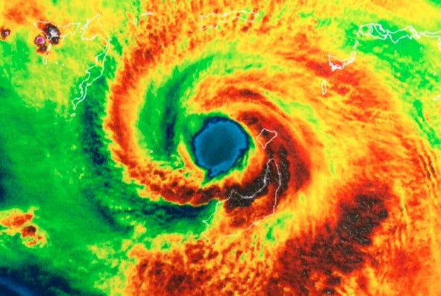
Image: Sciline
This thing we call “climate change” used to be “global warming.” That was better because heat is the core problem. Thanks to our greenhouse gases, Earth is absorbing more of the sun’s energy than it can reflect away into space. This additional energy stays here as heat.
The oceans are absorbing most of that heat. But starting about a year ago, the already-warming seas began warming even faster.
Unlike some climate statistics, we don’t have to deduce this from tree rings and other ancient history. We have reliable data from modern instruments.
Look at the chart below.
The faint gray lines show each year’s daily sea temperature from 1981-2022.
The black line is the 1982-2011 average.
The red line is 2023.
And the dark red line is 2024 through early March.
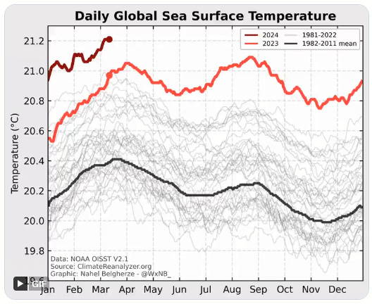
Chart: Nahel Belgherze
The oceans were much warmer in 2023 than the recent average. Starting in mid-March, every single day brought a global sea surface temperature higher than any year since 1981. And so far, 2024 is even warmer.
Something new seems to be happening on top of the global warming that was already underway.
What could it be?
One candidate is the periodic “El Niño” climate pattern, which warms the Pacific Ocean. It happens every few years and happened again starting last summer.
But sea temperatures had already begun the unusual climb months earlier. Climate scientists say the El Niño is certainly contributing but doesn’t fully explain this.
Another factor could be the January 2022 Hunga Tunga volcano eruption, which sent giant amounts of water vapor into the atmosphere. This would have had a warming effect, too. But again, the experts think it’s not a sufficient explanation.
Nothing else fits, either. These suddenly higher sea temperatures have the experts scratching their heads. They didn’t expect it and don’t know why it is happening.
Gavin Schmidt, director of NASA’s Goddard Institute, said in a recent New Yorker story, “We don’t really know what’s going on. And we haven’t really known what’s going on since about March of last year.”
University of Miami hurricane researcher Brian McNoldy says, “It’s not like we’re breaking records by a little bit now and then. It’s like the whole climate just fast-forwarded by fifty or a hundred years. That’s how strange this looks.”
In my experience, when scientists say they don’t know, they really mean they don’t know. They want to see more data before drawing conclusions.
For the rest of us, this kind of unresolved mystery is unsettling – especially if you live near the US Atlantic coast, where everyone knows from experience warmer water makes hurricanes more intense.
Here’s a chart like the one above, but this time for the North Atlantic. It shows the same kind of 2023 and 2024 anomalies.
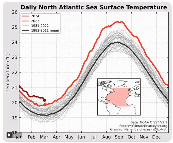
Chart: Nahel Belgherze
And here’s a map showing global sea surface temperatures in February. Orange and red shades mean that area was warmer than its 1991-2020 average.

Map: Jeff Berardelli
Note the area I circled in yellow. That’s “Hurricane Alley,” the ocean west of Africa where the storms that strike the US and Caribbean region typically originate. The water was very warm there compared to previous February data.
I am no weather forecaster but it’s really hard to imagine this is good… and easy to think it could mean more and worse hurricanes this year.
Cyclonic storms seem to be getting stronger as well as more frequent. Category 5 hurricanes have become so common, scientists are discussing whether to add a “Category 6” to the familiar 1-5 scale.
Last year’s Acapulco disaster was a terrifying example. Otis went from a run-of-mill tropical storm to a Category 5 hurricane in less than a day. Its maximum wind speed increased by 105 mph in a 21-hour period.
If you live anywhere near a coastline, this should get your attention. A lot of evidence says you should expect more storms, stronger storms, and possibly less warning time.
Nor is it just an east coast and Gulf coast thing. Otis hit Mexico’s west coast, the first recorded Pacific category 5 storm to make landfall. And this was the same year tropical storm Hilary struck California. Yes, a tropical storm hit California for the first time in 80 years. That ought to be a warning.
The coastal residents I know are pretty good at storm preparation. But I’m not sure they are prepared for what may be coming next.
If that’s you, consider using the next few months to get ready for a “worst case” storm far worse than anything you’ve ever seen.
Also, we should expect earlier storms and a much longer hurricane season. Traditionally, hurricane season starts on June 1, but SSTs are already the equivalent of mid-May (or even June in the tropics) of past years.
The number and intensity of storms in a season is notoriously hard to predict, but it's hard to see this upcoming season as anything other than wildly unprecedented and catastrophic.